Climate / average temperatures in ° C
February: 16° C at night, 30° C by day
April: 13° C at night, 29° C by day
Juni: 7° C at night, 22° C by day
August 9° C at night, 24° C by day
Oktober 12° C at night, 30° C by day
Dezember: 16° C at night, 30° C by day
WEATHER
The actual weather in Namibia you will find here!
CURRENCY
One (1) Namibia Dollar (N$) = 1 South African Rand (R). Für 1 Euro (€) you will get arount 19.80 N$ (04/2023) (exchange rates from today). Both Currencies are legal and accepted in Namibia. The Value Added Tax (VAT) is 15% in Namibia. Cash import in Namibia Dollar or Rand (R) should not exceed 500N$/R. Credit card like Master Card (Eurocard), Visa, American Express or Diners Card are mostly accepted. Guest farms and Lodges prefer mostly cash payments. After arrival at Windhoek Hosea-Kutako-International-Airport you can change your currency (also Sunday and Public holiday) at the airport as well as in several places in Windhoek.
Passport:
Your passport must be valid another six months over the entry date. For many countries, under that also Germany, no duty exists for an entry visa. Please ask your national government, if you need an entry visa for visiting Namibia.
Cell/Mobil phone
The biggest provider in Namibia is MTC. They are proud of covering 95% - of the Namibian population. You normally have no reception on remote farms or areas. Please make inquiries with your hunting provider, whether from there the reception is possible.
Tax & customs
The prices of all products and services contain 15 % value added tax (VAT) that you can get back.. On trophies which are exported no value added tax is raised.
Summer-/Winter time:
Summer time: From the first Sunday in September up to the first Sunday in April GMT/world time +2 hours is the time in Namibia.
Winter time: The GMT/world time +1 hour begins on the first Sunday in April and lasts up to the first Sunday in September.
Flying from Frankfurt/Main in Germany you will land after approx. 10 hours direct flight on the international airport "Hosea Kutako", which is situated approx. 35 km in the east of Windhoek. Normally your hunting provider will get you there and carries you to the hunting ranch etc. or here starts your round trip with a hired car (on own fist), with a touristic business (guided tour) or you drive with a taxi to the national airport in Windhoek (Eros Airport), in order to fly from there with a small airplane to the place of your choice..
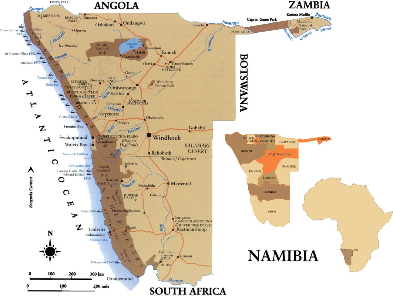
Namibia's capital Windhoek
Windhoek, Namibia's capital, nestles among rolling hills, bounded by the Eros Mountains in the east, the Auas Mountains to the south and the Khomas Hochland to the west. It is a meeting place between Africa and Europe, the modern and the old. In the capital's main street, well-preserved German colonial buildings are in sharp contrast with modern architectural styles, while Herero women in their traditional Victorian dresses mingle with executives dressed in the latest fashion. A coloured nation mixture dominates the streets of this with 400.000 inhabitants biggest town of Namibia. Here you can shop as desired or stay in one of the many restaurants. Overlooking the small central business district is the landmark Christuskirche, the Alte Feste (old ford), the oldest building in Windhoek, and the historic Tintenpalast (Ink Palace); the seat of Namibia's Parliament. In any case you should have an over night stay in Windhoek. Tip: Enjoy the fascinating sunset above Windhoek from the terrace of the Heinitzburg or Hotel/Pension Thule.
Okahandja
On the way to the north of Namibia you pass by the city Okahandja. Okahandja is until today the most important traditional centre of the Herero, where their big leaders Tjamuaha, Maharero, Samuel Maharero, Hosea Kutako and Clemens Kapuo are buried. For their memory and in memory of the battle at the Waterberg the traditional Herero days occur here annually in August - it is one of the most colourful cultural events in Namibia with however increasingly touristic character. From special touristic importance is the big wood carvings market, the Ombo Ostrich Farm and the historic Rhenish Mission Church.
Waterberg
The Waterberg is a prominent plateau in Namibia, north of Windhoek, which towers 200 - 400 m above his environment. Originally regarded as the heartland of Namibia's Eland, the 40.500 ha large park was established in the early seventies as a sanctuary for the rare and endangered game species of the Caprivi, for which an extensive relocation programme was carried out. The Waterberg Plateau Park is home to 25 mammal and over 200 bird species. The park can only be explored on foot by means of self-guided wilderness trails, or by vehicle on a guided game-viewing excursion offered by conservations officials. The Namibian government established the Bernabé-de-la-Bat-Camp around the former German police station for tourists. Accommodation at Waterberg is in the extensively refurbished Waterberg Camp with its luxury chalets, restaurant and the large camping site set under huge camel-thorn trees, as well as Waterberg Wilderness in the near vicinity.
Otjiwarongo
The town of Otjiwarongo , a Herero word meaning "a good place" is an important centre for cattle ranching. An interesting feature is the Otjiwarongo Crocodile Ranch, where crocodiles are bred. The town is seat of the AfriCat Foundation which devoted to the protection of the African big cats. The AfriCat Foundation, founded in 1992, is a non-profit based organization, which bothers for the receipt and protection of the African big cats, in particular of cheetahs and leopards.
Caprivi
The Caprivi (Caprivi-Zipfel) lies in the utmost northeast of Namibia, over 1.000 km far from Windhoek. The narrow, almost 400 km long country corridor, extends up to the Zambezi and borders in the north on Angola and Zambia, in the east on Zimbabwe and in the south on Botswana. In order to explore this area and to find out the full splendour of this natural landscape, you need some days. Several with water filled rivers in a full-year way like Okavango, Kwando and secondary rivers of the Zambezi flow through the Caprivi and it like this to an expressly moist and therefore also very game-rich area: Here Cape Buffalo, Elephant, Lion, Leopard, Hippo, Crocodile and many rare kinds of antelopes move their trails.
Big parts of the Caprivi are nature reservations and are therefore an increasing destination of touristic activities - an evolution, which is supported by the continuous asphalting of the meanwhile in a full-year way passable national route B8. The Caprivi is not only Namibia's access to the water of the Okavango and thus importantly for the economy of the area, but is also discovered again increasingly by tourism. So it forms the starting point for journeys to the Zambezi, the Victoria Falls and to the Okavango-Delta. In addition here are the Liambezisee, as soon as the Caprivi National Park and the Mudumu National Park. A special touristic attraction are the Popa Falls of the Okavango.
Tsumeb / Grootfontein
Tsumeb is the mine town Namibia's. Starting in 1905 the town of Tsumeb was closely linked to the mining industry, but mining operations have since been scaled down considerably. The colourful jacarandas, flamboyant trees and bougainvilaca that lines Tsumeb's streets have earned in the name of Namibia's garden town. The history of Tsumeb is depicted in the Tsumeb Museum, where a comprehensive collection of rare minerals can be viewed. In the Khorab Room This section displays a collection of restored cannons and other armaments dumped into Lake Otjikoko by retreating German forces shortly before the signing of the Khorab Peace Treaty.
The largest known meteorite in the world, the Hoba-Meteorit, lies in a shallow depression on the Farm Hoba-West, about 20 km west of Grootfontein. The 50 / 60-ton mass of nickel and iron, which is between 190 and 410 million years old, crashed to earth some 30.000 to 80.000 years ago. Discovered by Jacobus Hermanus Brits in the 1920's, it was periodically subjected to vandalism. Measures to protect the meteorite were taken in the 1980's in a joint venture between Rössing Uranium Ltd and the National Monuments Council. A stone amphitheatre was built around it to allow for convenient viewing, while a museum wall giving information on the meteorite was built at the entrance. There are barbecue facilities at the site, and an interesting variety of birds.
Etosha National Park
The internationally known Etosha National Park is an 22.275 km² large conservation area in Namibia's north and one of the largest parks in Africa. The name „Etosha" comes from the Oshivambo and means „big white place". Etosha owes its unique landscape to the Etosha Pan, a vast shallow depression of approx. 5.000 km². A series of waterholes along the southern edge of the pan guarantee rewarding and often spectacular game viewing. In good rain years the pan fills with water draining southwards from Angola via a delta-like system of shallow rivers and oshanas, drying out in the winter to become an austere expanse of white cracked mud, shimmering with mirages and upward-spiralling dust devils Etosha has three tourist resorts- Okaukuejo, favoured for its floodlit waterhole where "specials" such as Elephant, Giraffe, Black Rhino and Lion can be viewed at night; Namutoni, characterised by the historic fort around which it is centred; and Halai, situated halfway between Okaukuejo and Namutoni. You can drive through the park on gravel pads with your own car. There are many lodges and guest farms situated close enough to Etosha that allow for a day excursions into the park. Here you should stay at least for 2 days.
Rucana Falls, Kaokoveld, Epupa Falls
In the Ruacana Falls the Namibian-Angolan boundary river Kunene throw over 120 meters deep into a 700 meters broad gorge. They wear their name to the near sited district town Ruacana. There are two hydropower stations directly at the waterfall, one of them which was built in the 1970'th is the biggest electric power station of Namibia. Through the use of the river water for the electric power production the waterfall offer his impressive play only at high water. This has made it to a known tourist destination.
In the north-west of the Etosha Pan the Kaokoveld with his bitter beauty is located - a mosaic from sandy tiers, rough mountains and jagged slopes, whose northern boundary is the Kunene River. The Kaokoveld was about many generations the home of the initial Himba clan, who has retained his nomadic way of life still until to day. Small herds of Desert Elephants migrate along the river valleys, accompanied by Giraffes, Gemsbuck and Springbuck herds.
The Epupa Falls (in the language of the Herero Epupa means 'falling water') are in the course of the Kunene, the boundary river between Namibia and Angola. Through the junction of different water-rich rivers from the highlands of Angola the Kunene is the river with the highest flowing-rate in Namibia. It rinsed narrow gorges in the otherwise arid Kaokoveld.
Skeleton Coast, Khorixas, Twyfelfontein
The Skeleton Coast with the cold Atlantic Ocean in the west is truly called the largest graveyard of ships of the world. Here innumerable ships stranded, the survivors died of thirst afterwards in the Namib. The Skeleton Coast is a secluded, human being empty strip of coast, which attraction are the sand dunes, gravel tiers salt pans united with its absolute loneliness. The coast offers very good fishing possibilities.
Among many other sights west of Khorixas in Damaraland the Petrified Forest and Twyfelfontein with its concentration of more than 2.400 rock engravings and paintings are a necessity to look for. In the proximity also the Burnt Mountain (Brandberg) and the Organ Pipes, a mass of basalt slabs in a ravine gouged out by a river are to be found. Dominating the landscape is the Ugab Vingerklip (Finger Rock) situated amongst the 80 km long rugged Ugab Terraces. About 35 m high, this distinctive monolith has been moulded into its curious shape by erosion spanning many millennia. Between Omaruru and Swakopmund the Spitzkoppe dominates the desert plan. This 1.728 m high isle mountain, sometimes referred to as the Matterhorn of Namibia, is a popular and severe test for any rock climbers.
Swakopmund, Walvis Bay, Cape Cross, the Dunes of the Namib, Namib Naukluft Park
Swakopmund, mentioned also the "Baltic Sea bath of Namibia", is starting point of many Excursions to the nearby sights and beauties of nature. Here you should stay also for a few days in a congenial retirement and start your excursions from here. Swakopmund is situated near the delta of the Swakop River, framed from dunes and the Atlantic Ocean. Since a long time Swakopmund is a popular vacation destination and a tourist stronghold of the country. Here you find clear signs of former German colonial time and mainly German speaking Swakopmunder. You can taste typically German confectioner products in the cafés of the town and make enjoy delicious fish specialities in the evening in one of the numerous restaurants or surprise yourself from the "catch of the day". Known historical buildings are the Woermann House, the old railway station, the old courthouse and the old pier "Jetty": Here economic products and war material of the German colonial power were landed for a short period; to day the pier is the meeting point of amorous couples. The old lighthouse showed the sailors and their ships the way to that place.
Walvis Bay is located approx. 40 km south of Swakopmund. Also framed from the dunes of the Namib and the Atlantic Ocean and a far expending lagoon, Walvis Bay is the biggest sea port of Namibia and the centre of the Namibian fishing industry as well as also a rapidly growing touristic industry. The Walvis Bay wetlands are international known for their plenty available shallows birds as Flamingos. The steadily blowing winds from southwest offer ideal conditions for surfboarders and other water events in the lagoon. At the south edge of the lagoon white mountains arise in the height: Salt, produced by vaporization of sea water and piled up for the transport. The coast dunes facilitate the most different adventurous activities as dune skis (on Dune No. 7), sand board sails, paragliding and quad biking.
In Sandwich Harbor, approx. 40 km south of Walvis Bay, the dunes of the Namib flows into an ancient, nature left lagoon (former sea port) and produce a spectacular coast landscape. Sandwich is also one of the most famous wetlands of Africa. It is only open to all-wheel drive vehicles (fundamentally necessary, if you wants to go off fortified roads) and is opened only for day visits.
Approx. 100 km in the north of Swakopmund Cape Cross (Kreuzkap) is located. The Cape Cross is on of the biggest and particularly open for visitors crowd of the South African Fur Seals. Here they form a colony of up to 250.000 animals to give birth to their youngsters in October or November. In this concentration the seals represent a genuine problem for the fishing industry, because seals daily eat about eight percent of their dead weight at fish. In order to prevent an over-population, seals are hunted at the Cape Cross annually in greater numbers and used for shoes and bags. In January 1486 Diego Cão entered the country tip presumably as the first European at 21° 46′ of southern width and constructed a stone cross there. This original was removed in 1893 by a German captain, transferred to Germany (Berlin) and replaced by a simple wood cross. Two years later the wood cross was replaced also by a copy of stone at Cape Cross. At the end of the 20th century a further new stone cross - the original rather corresponding - was joint. This was possible due to private donations so that to day two crosses are to be found at Cape Cross.
According to the season there is a lot of fog at Swakopmund area, which is formed while cold air of the Atlantic Ocean meets on hot air from the Namib. It stays sometimes the whole day long and solves, when anyway, only in the late noon. Only in the Namibian summer (December until March) almost no fog formation occurs. If therefore you want to flee from this fog, you start a day excursion through the Namib into the northern part of the Namib Naukluft Park. With an all-terrain space wheeled vehicle you drive past flourishing plantations along the Swakop River or also in the dry river itself (here is built on vegetable- also asparagus, and fruits- also bunch of grapes, because the Swakop River leads water in an underground way). After few kilometres the fog is cleared and the Namib develops with full splendour in the glistening sunshine in front of you. Past at the old mail station with separate kraals for the draught oxen and accommodations as well as brothel for the coachmen banished into this solitude by the Swakopmunder, because the stink of the ox dung and the many flies nerved them), you will experience the nature in a breath-taking variety of sand, gravel, stones, gorges, dunes, plants (Nara melon etc.) and animals (Klipspringer etc.). After a short hold at the "sounding stones", here the San (Bushmen) have contacted themselves by beating with a stone onto a bigger hollow stones, you will come after crossing the "moon landscape" to a miraculous plant: "Welwitschia Mirabilis", which adorns also the state coat of arms of Namibia due to the relatively frequent occurrence. These several a hundred years old plants with up to 2,50 meters long leaves take on the water that drips through fog moisture from their leaves onto the subordinate root system. It is also claimed however, they would have roots up to the groundwater.
Sossusvlei, Dead Vlei, Sesriem
Many visitors to Namibia say that no part of the desert is visually more stunning than Sossusvlei, a big clay pan with its monumentally high dunes. These gigantic star-shaped mountains of sand - one of the largest was measured from the base to be 325 m high - are a sought-after topic for artists and photographers. The warm tints of the sand contrast vividly with the dazzling white surface of the large deflationary clay pans at their bases. One of these, referred to as Dead Vlei/Pan, is a large ghostly expanse of dried white clay, punctuated by skeletons of ancient camel-thorn trees, carbon-dated as being between 500 and 600 years old. Sossusvlei mountainous dunes lie at the end of an erosion trough formed by the Tsauchab River. They are shaped by strong multi-directional winds, primarily the southwester, and three to five sinuous crests, which meet at the highest point to give them their star shape.
The permit office complex for entry to Sossusvlei and other destinations in this part of the park is at Sesriem. Four kilometres south from here is Sesriem Canyon, where the erosion of many centuries has incised a narrow gorge about 1 km in the length, formed by the Tsauchab River in former times. At the foot of the gorge, which plunges down 30 - 40 metres, are pools that become replenished after good rains. Sesriem derives its name from the time when early pioneers tied six lengths of rawhide thongs together to draw water from these pools.
The Duwisib Castle also is a known attraction of the southern Namibia. It was built by the legendary Baron Hans-Heinrich von Wolf in 1908/1909 and is situated in the rolling red hills south west of Maltahöhe. This German fortress with its 22 rooms is one of the greatest curiosity in Namibia.
West of the small town Aus in direction of Lüderitz the landscape looks like an infinite plane, which melt with the sky at the far horizon. Here is the home of the wild horses of the Namib, one of the few stocks of desert horses in the world. Lüderitz has developed since 1908 right in a rock landscape when diamonds occurrences were discovered then there. With plenty of German colonial buildings Lüderitz did survive the time and the rough weather of the decades, which was not the case of other mining industry settlements as Kolmanskop, Elisabeth Bay and Pomona. These were left suddenly and changed therefore to ghost towns. The country then forced out of the Namib for the building of houses fetches back the desert to itself now again. In many places only still the gables of the former in part very much neat buildings look out of the hot desert sand.
The Fish River Canyon, which was rinsed by the Fish River on a length of about 160 km and width of up to 27 km up to 550 meters deeply is the second largest canyon Africa's and one of the largest in the world. The Fish River is the longest river of Namibia with a length of more than 650 km. It originates in the eastern Naukluft Mountain, leads water, however, exclusively in very rain-strong times below its dam up at the Hardap-Dam. From that not only the future erosion of the river bed is minimized, but also the vegetation at the coarse of the river will change with the time being. In spite of that individual pools can be found in the river bed even in rain-poor times, which are to be fed probably from groundwater the whole year. This pools are used as well by some antelope species as by leopards. The canyon was declared not at last therefore as the a nature reserve and appertains in part to the state Fish-River-Canyon-Nationalpark and partly to the private 440 km² large Canyon Nature Park. The Fish River Canyon begins at Seeheim in the north and ends at Ai-Ais in the south, while the river flows some kilometres after that into the Oranje River, the boundary river to the Republic of South Africa. The two main camps of the park are Hobas near the main lookout with the information centre at the north end and Ai-Ais with its hot springs in the south. For tourists more-daily guided excursions, approx. 85 km long, are offered from May till August through the canyon; on the other hand a descent without guiding is life-dangerous and therefore forbidden.
As a report of the foundation history of Keetmanshoop some buildings still exist from the time of the German colonial domination. The Church of the Rheinische Mission, built in 1895 of granite, is the seat of a home museum to day, which shows a full overview of the town history. The "Imperial Post Office" from the year 1910 houses the tourist information office to day. Also preserved from the year 1908 is the railway station building.
A special touristic attraction is the approx. 20 km northeast of Keetmanshoop sited Quiver Tree Forest. This group of prehistoric trees of approx. 300 specimens is sited on the ground of the private Farm Gariganus and stands since 1955 under nature conservation. The name refers to the state of the wood. Because this is easy to hollow out, the formerly resident people of the San and Khoi Khoi produced quivers from the boughs of the tree, in which they carried their hunt arrows.
From Keetmanshop the way goes back to Windhoek, with that the virtual journey over almost 3.500 km finds its end. I hope you enjoyed it.
1. Namibia is a secure, clean and exciting travel destination.
2. If you rent a car, select a vehicle which is a cross-country vehicle (4x4) if you want to undertake "off road-tours".
3. You need an international driver's license for the driving of a vehicle in Namibia.
4. Go in pathless areas fundamentally only with two vehicles.
5. Adapt your km-rate to the respective street circumstances. The unusual left-hand traffic and too high rate on
macadamized roods are the main cause of most traffic accidents.
6. Take, if possible, two reserve tires with you. Namibia's gravel pads / macadamized roads are tire killing! Make
yourself familiar with the carriage lever of your rented car.
7. Refuel your vehicle in time. The next service station might be empty or can be up to hundreds of kilometres far away.
8. Take always sufficient water with you, also for the case, that you have a break-down or get stuck.
9. Deposit your travel plan /route with your travel agency, hotel or friends and get in contact with them in a step-by-
step way by telephone.
10. Take a good rood map with your, which is up to date.
11. Often animals cross the road or graze near the street. Game and domesticated animals often shy and can slightly
jump directly in front of your car. The weight of a Greater Kudu bull is approx. 350 kg!!
12. Avoid driving at night; here the danger of a collision with game animals is especially great.
13. Dispose your waste carefully and respect the customs and rites of the local population.
14. Use your healthy human intellect at all times and make the same safety measures in Namibia, that you
would think they are opportune also at home and anywhere in the world.